Almost everything worth doing here is outside, above 2,000 m, and reached by a road. That makes the planning unusually simple and the timing unusually important: the same viewpoint is transcendent at four in the afternoon and flat and grey at eleven in the morning. Here is what to do, what it costs as of August 2026, and when to be standing there.
Quebrada de las Conchas: the free one
Three hours of red canyon on the way to the wine, and it costs nothing.
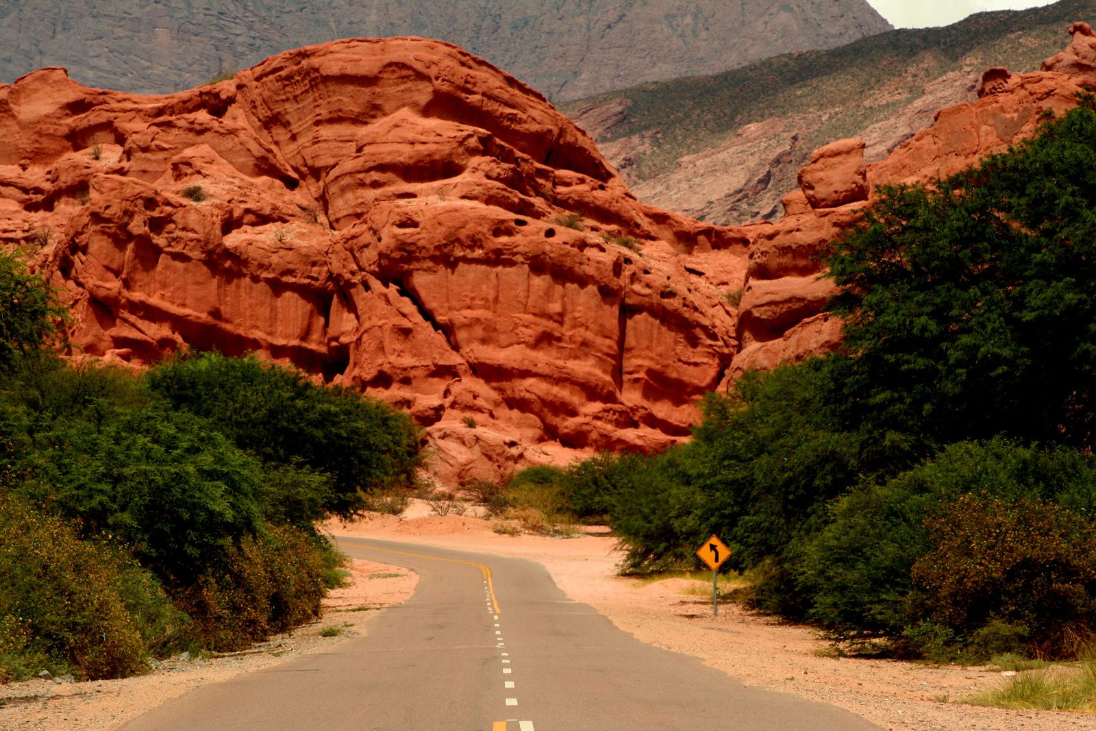
RN68 runs about 190 km from Salta to Cafayate, roughly three hours if you don't stop, and the last stretch is a red sandstone canyon that most people drive past on the way to a bodega. Don't. The viewpoints and the parking are free and unstaffed, which in 2026 makes this the best-value thing in the region by an absurd margin.
The two to stop at: El Anfiteatro, a natural rock bowl with acoustics good enough that there is usually somebody inside it playing charango or quena, and La Garganta del Diablo, a dry waterfall carved into a slot between two walls. Both are metres from the road. Both take fifteen minutes. Both are better in the late afternoon when the rock goes properly red.
Practical: this is a drive, not a hike, and it is entirely paved. If you are doing Cafayate as a day trip you will be driving back through this in the dark and missing all of it, which is the argument for sleeping in Cafayate.
Salinas Grandes, and the guide you have to hire
4,170 m to get there, and a community-run system most write-ups don't mention.
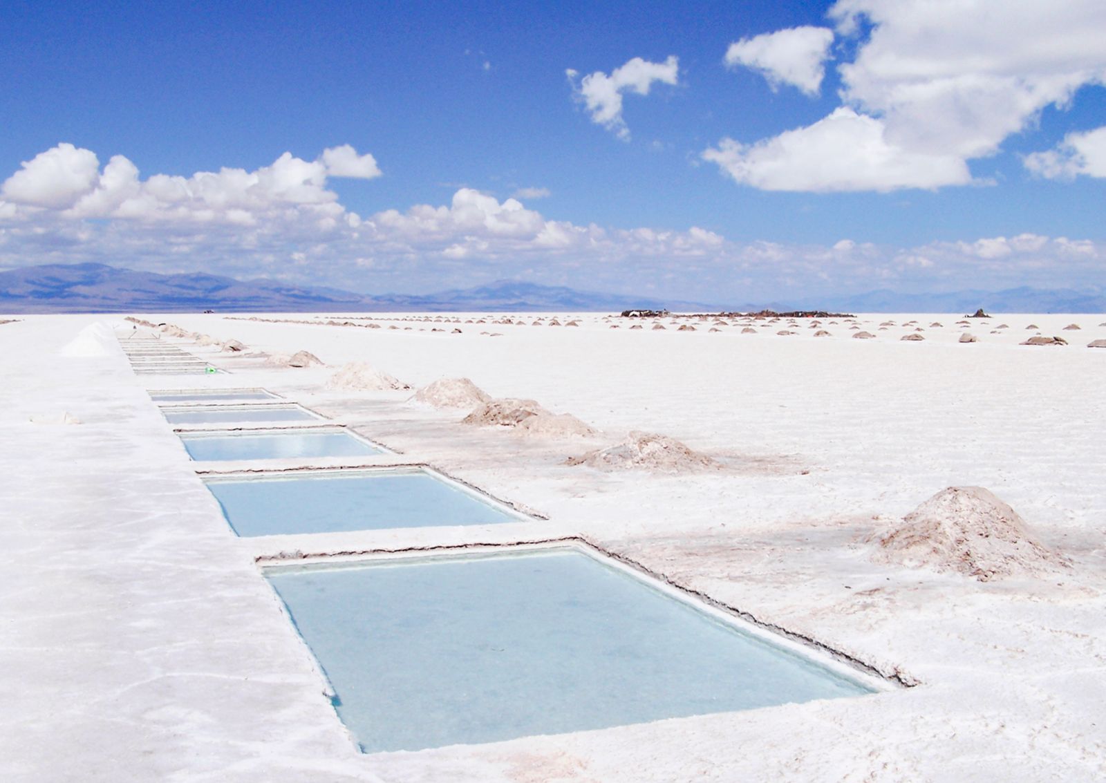
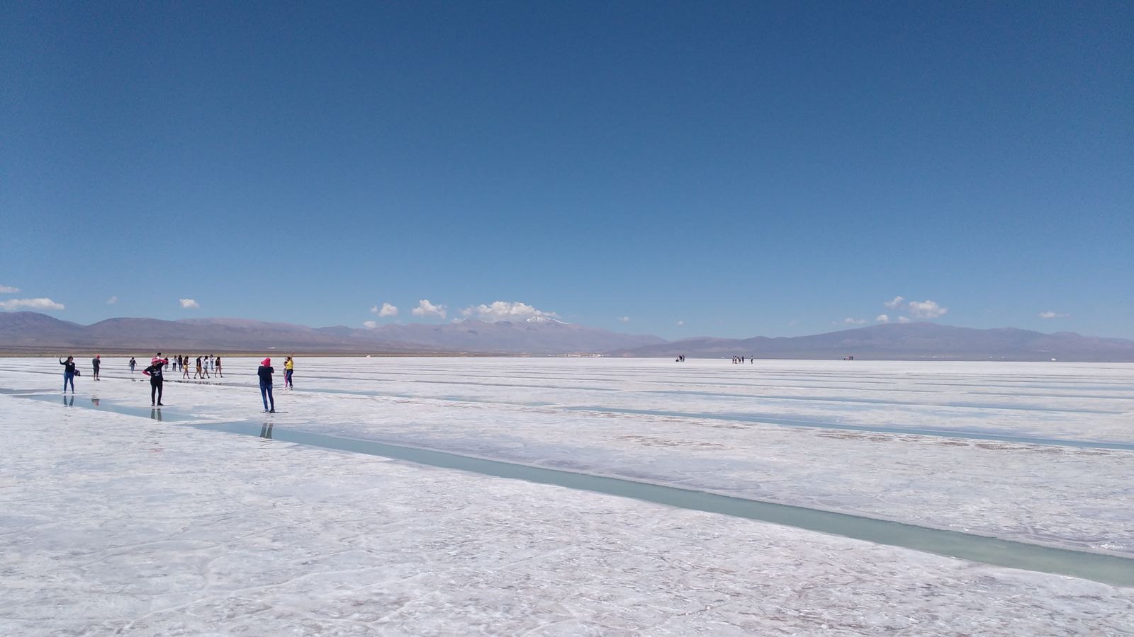
From Purmamarca, RN52 climbs the Cuesta de Lipán to 4,170 m and drops onto the altiplano, 66 km of good tarmac to a salt plain that runs flat white to the horizon. It is genuinely disorienting, in the good way.
Two things nobody tells you before you go.
First, the guide is not optional. To go out to the piletones — the cut pools where the salt is worked — and the ojos de agua, you hire a guide from the local communities at the lodge at the entrance. It was $8,000 per person from age six when last checked (November 2025; assume higher now and confirm at the lodge). You drive your own vehicle and a local guide leads on a motorbike, marking the route across the crust. The circuit runs about 45 minutes. This is a community-run operation on community land, and paying it is the deal, not a tourist tax.
Second, there is no public transport. Either you drive, or you buy a seat on an excursion from Purmamarca, Jujuy or Salta.
Timing: go in the morning. The light is cleaner, the wind is lower, and you will be at 3,450 m on a white surface with no shade whatsoever — sunglasses, hat, and far more sunblock than feels reasonable. If any of your group slept at sea level two nights ago, read the altitude section of the comprehensive guide before you commit to this day.
The Cuesta de Lipán, at 4,170 m
The pass is the day, as much as the salt flat is. The road climbs in long switchbacks out of Purmamarca and tops out at 4,170 m with a view back down the whole Quebrada. There is a pull-off at the top and everybody stops. When you get out of the car, move slowly: this is 4,170 m, and the reason people feel terrible here is almost always that they leapt out for a photograph. Walk. Breathe. Take the photograph anyway, just take it at half speed. The road carries on west to Paso de Jama and Chile, which is worth knowing if anyone in the group is dreaming about the Atacama.
The Hornocal, and the light
Fourteen colours at 4,350 m, and a three-hour window when they show up.
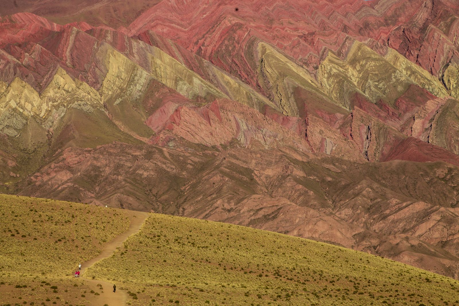
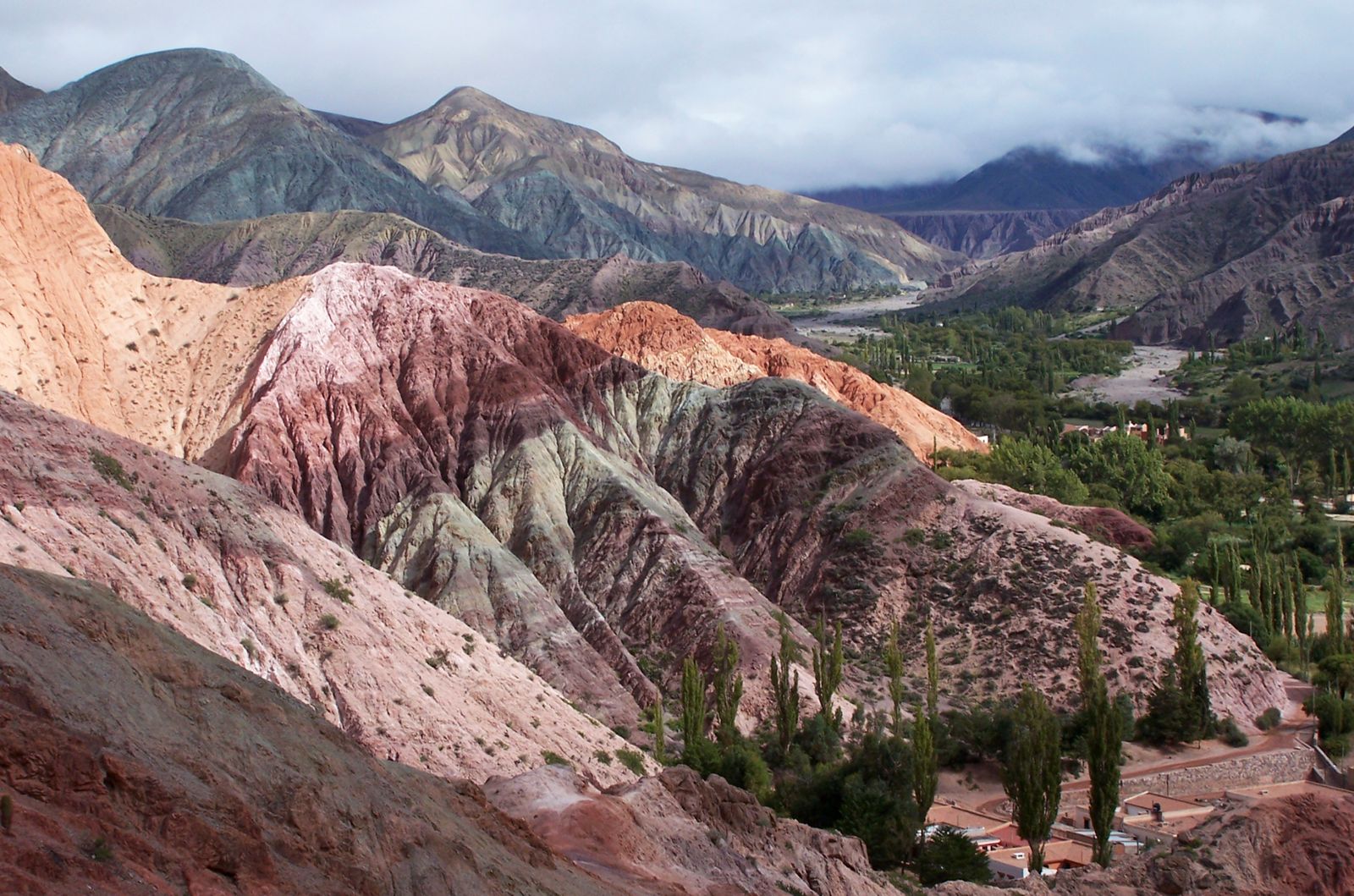
The Serranía del Hornocal is a wall of folded limestone above Humahuaca that comes out in something like fourteen distinct mineral bands. It is the more spectacular sibling of Purmamarca's seven-colour hill and far fewer people bother, because getting there is work.
It is about 25 km from Humahuaca on RP73, unpaved, climbing to a viewpoint at 4,350 m. Cross the bridge over the Río Grande two blocks north of the bus terminal and stay on the main route, ignoring the turnings to Coctaca and Ocumazo. A 4x4 is not required; a vehicle with decent clearance and functioning everything is. Rain leaves the road rough, so ask in Humahuaca before you set off — the tourism office, the service station or the police will tell you straight. There is a small entrance fee, a couple of dollars, in cash.
Then the part that decides whether the trip up was worth it: go between about 15:00 and 17:00. Earlier and the sun is behind the ridge and the whole wall reads as grey-brown. In the late afternoon it lights up frontally and the bands separate. Budget about three hours from Humahuaca all in — an hour up, an hour there, an hour back — and you'll be driving down at dusk, so leave enough light.
Same warning as the salt flat, more so: this is 4,350 m, the highest most people in your group will ever have stood. Get out of the car slowly and don't walk uphill to the better angle at speed.
Pucará de Tilcara and the Garganta del Diablo
A pre-Inca hill fort and a gorge walk, both from the same village.
Tilcara is the best base in the Quebrada and it has two things you can do on foot.
The Pucará is a reconstructed pre-Inca fortified settlement on a ridge above the village, with a commanding view up and down the valley, which is of course exactly why it's there. Run by the University of Buenos Aires. As of August 2026: $12,000 general, $6,000 for Argentine residents, free for under-12s, Jujuy residents and jubilados. Open Tuesday to Sunday, 09:00 to 18:30, last entry 17:15, closed Mondays — note the Monday closure, it catches people constantly.
The Garganta del Diablo above Tilcara is a gorge and small waterfall about three hours' round trip on foot from the village, with an entrance fee of $5,000 (checked July 2026), open 09:00 to 18:00. It's a steady uphill at altitude rather than a technical walk. If the group's legs or lungs aren't up for it, the local agencies run it as a short 4x4 trip instead.
Do the Pucará in the morning and the gorge after lunch, and finish at La Casa de Champa for tea, which is in the food guide and is the correct end to that day.
The Tren a las Nubes, honestly
The famous one. Worth it for some people, and there's a road to the same bridge.
The Tren a las Nubes is the region's headline excursion: a full day from Salta, out across the Valle de Lerma and up the Quebrada del Toro to the puna, ending at the Viaducto La Polvorilla — a curved steel trestle 63 m high at 4,220 m, one of the highest railways in the world. The return leg is by coach. It runs four times a week, has a dining car, doctor and bilingual guides, and is suspended for roughly ninety days over the austral summer because that's landslide season. Being a high-mountain excursion, it can also be cancelled for weather on the day.
The money: fares rose from July 2026 to around $210,000 for national tourists and about $62,000 for Salta residents, across turista, ejecutiva and premium classes. The operator publishes no fare table and quotes by date at booking, so treat those as the shape of it and get a real number from them before you plan around it.
Our honest take: if you want to ride a famous train through the Andes, ride it — it is a genuinely extraordinary piece of engineering and the dining car at 4,000 m is a good story. If what you actually want is to see La Polvorilla, know that you can drive there. Take RN51 west to San Antonio de los Cobres, then RP74 for 14 km. There is also a shorter train-only service that departs from San Antonio de los Cobres station, which you can reach by car. Same viaduct, a fraction of the day and a fraction of the cost, and you keep control of your own schedule. For a group of six that difference is real money.
Ride the train because you want the train. Don't ride the train because you want the bridge — the bridge has a road to it.— On the Tren a las Nubes
Iruya, if you have the day
A village on a cliff, 54 km of gravel and a 4,000 m pass away.
Iruya belongs to Salta province but the only road in comes from Jujuy, which tells you most of what you need to know about it. From Humahuaca it's 21 km of asphalt on RN9, then 54 km of ripio: up to the Abra del Cóndor at 4,000 m, the provincial boundary, then down to Iruya at 2,780 m, stacked on a slope above a river confluence with a white church at the top. About three hours each way.
It is the most committing thing in this guide and the one people talk about longest afterwards. It is also a genuine full day, on gravel, over a 4,000 m pass, in a rental car whose contract you should have already checked. Between April and November the first and last bus services take a detour via Colanzuli, which adds about fifteen minutes and is the prettier road.
Do it if you have eight nights. Skip it if you have five, and put the day into the Quebrada instead.
Where we would book
Almost nothing on this page needs booking, which is unusual and worth saying plainly. The Quebrada de las Conchas viewpoints are free and open. The Salinas Grandes guide is hired on arrival at the lodge and cannot be booked ahead — anyone selling you "skip the queue" access to a community-run salt flat is selling you something that doesn't exist. The Hornocal fee is paid at the barrier in cash. The Pucará you pay at the gate.
The exception is the Tren a las Nubes. Buy that direct from the operator, who prices it by date, and buy it early in the high season. If you'd rather drive to La Polvorilla, you need nothing but fuel and a full day.
For Iruya, if you'd rather not drive it, agencies in Humahuaca and Tilcara run it and their drivers know the road in a way you won't on the first attempt. That is one of the few places on this trip where paying somebody is clearly the better call.
Related guides
- Salta & Jujuy Travel Guide — the altitude order, the car small print and the week's shape.
- Salta & Jujuy Food Guide — where to eat between the viewpoints.
- Salta & Jujuy Culture Guide — what the Quebrada actually is, and whose road it was.
- Salta & Jujuy Group Trip Guide — one vehicle, six people, and the gate fees that add up.
- Buenos Aires Activities Guide — what to do at 25 m above sea level, for contrast.